


 24/7 Emergency Service
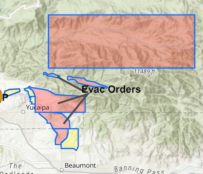
El Dorado Fire Up To Date Information
9/10/2020 (Permalink)
 More information can be found at KESQ.com or Sbcounty.maps.arcgis.com
Update 12/22/2020
According to inciweb Post-fire emergency preparedness for local residents:
"Residents and visitors in the fire area should be aware that recently burned areas are at a greater risk of mudflows and flash floods. Fires eliminate vegetation that hold soil and rocks in place and charred ground may be unable to absorb water. Forest Service Burned Area Emergency Response (BAER) Teams and CAL FIRE Watershed Emergency Response Team (WERT) efforts are focused on the protection of human life, safety, and property. Rapid burn assessments identify areas that have increased potential for floods and mudflow, enabling county, state, and federal emergency managers to better plan their responses to future rain events. For more information, please visit the El Dorado Post-Fire BAER InciWeb page.
Residents in the mountain and foothill areas should stay informed of weather forecasts. Register your cell phones with the Telephone Emergency Notification System (TENS) / Swift 911 and have an emergency plan. Visit www.sbcounty.gov for more emergency preparedness information."
************************************
As of 9:00AM 9/10/2020 The El Dorado Fire is 23% contained, with 12,610 Acres burned. 4 homes have been destroyed and 2 have been damaged in Oak Glen, According to KESQ News Chanel 3.
NEW EVACUATION ORDERS:
All areas between Angelus Oaks and Onyx Summit have a mandatory evacuation. Residents to evacuate via highway 38 to Big Bear.
Oak Glen Rd to Highway 38, West of Bryant to Garnet.
For a full list of evacuation orders see attached map from San Bernardino County Maps.